I’ve heard the legends of having to drive to literally everywhere (e.g. drive thru banks), but I have no clue how far apart things are.
I live in suburban London where you can get to a big supermarket in 10 minutes of walking, a train station in 20 minutes and convenience stores are everywhere. You can get anywhere with bus and train in a few hours.
Can someone help a clueless British lemmyposter know how far things are in the US?
EDIT
Here are my walking distances:
- To the nearest convenience store: 250m
- To the nearest chain supermarket: 350m
- To the bus stop: 310m
- To the nearest park: 400m
- To the nearest big supermarket: 1.3km
- To the nearest library: 1.2km
- To the nearest train station: 1km
Straight-line distance to Big Ben: 16km
It’s not necessarily how far things are, it’s that you need a car to get to places in a sensible way.
I’m a fellow Brit, but have stayed in suburban US enough to have experienced how different it is. You might have a supermarket a couple of miles away, but if you want to attempt to walk there, you’ll often be going well out of your way trying to find safe crossing points or even roads with paved sidewalks.
Train stations are mostly used for cargo in most US cities. If you don’t have a car, you’re pretty much screwed.
Some cities are different. NYC being the obvious one. You can get about there by public transport pretty easily in most places there. San Francisco is another city that is more doable without a car, but more difficult than NYC.
I stayed near Orlando not too long ago and there it’s just endless surburban housing with shops and malls dotted about mostly along the sides of main roads. You definitely need a car there.
Denver isn’t great with public transport either. There’s at least a minimal light rail system and buses go pretty much everywhere, so that’s the good part, but the city is so sprawled out that unless your destination is a direct route you’re looking at an hour or more to exclusively use public transport. And that’s really the main city. Start getting out into the expanded metro area and there’s not many choices except for a handful of spur rail or bus lines.
It’s a lot more than many American cities, especially on paper, but in practice it’s pretty rough to use as a primary transport.
Most bus systems in American cities are for people to get to work and back home. Trying to take it to, for instance, a friend’s house, and you’re generally going to spend about 4x the time it’d take to drive there.
Great question. London is amazing for being able to walk around, and has amazing transit. I honestly love your city, and may move there someday for it. This is mostly because London embraced transit in the early 20th century.
America went the other way, and embraced the car, and that pushed for the “American Dream”. Suburbs became the normal, where people wanted an independent house farther away from the city. From there bred new problems, people needed to be able to drive their car there, which meant we needed more parking, which meant that things became further and further away.
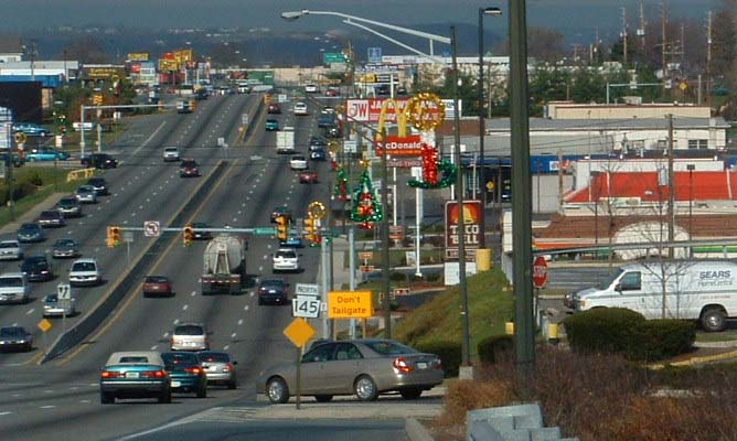
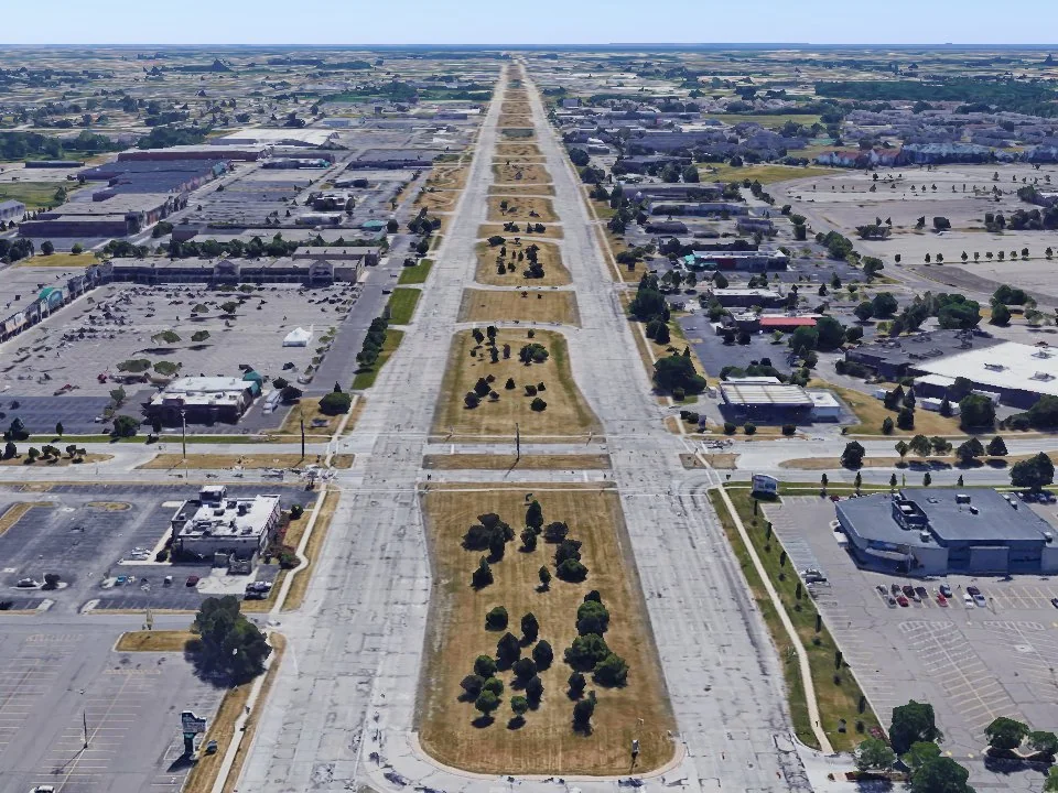
You can actually blame parking for most of America’s sprawl. Parking eats up a ton of space, and requires large roads to get people where they need to go and then massive parking lots for people to park their cars. Parking lots you can’t even understand in your London mind. Then there are new problems - the parking lots are so massive that now you can’t even walk to the building next door because it’s half a mile just to walk to that place! So people get in their cars to drive across the street to park in the next place. This isn’t exaggerated, that’s just how it is. Take a look at this shopping center in Des Moines, a city where I grew up.

Americans designed cities for cars, not people. There is no way that areas like that were built for humans to move around in, it was built for people to drive to. Greenspace or walkways are not a thing, you are meant to park, walk for hundreds of meters to the front of the door, shop, and then get back in your car and drive across the big street to go to dinner. (To boot, most places won’t let you leave your car either, if you’re done shopping you need to move it).
The real problem is that this is all by design. We kill so much space in our cities so that drivers feel more comfortable. Honestly, I really appreciate London and how well they’ve done. Remember all of this next time your PM wants to “make it easier for drivers”. No. Fuck the drivers. They’re driving their huge metal car into your city, and wanting to have it take up space all so they don’t have to walk or take a train/bus. They should have to pay extra for renting space from the city.
Amazing video on why parking is so freaking stupid in America: https://www.youtube.com/watch?v=OUNXFHpUhu8
I love how London made most residential roads 20mph so I can bike without feeling like I’m about to be crashed into at any second
I just tried to bike for the first time in my neighborhood. For half of the road there was a bike lane, and it was a ton of fun! Then that section ended and I had to merge with traffic - where I had cars swerving around me and making me feel like I somehow inconvenienced them.
The average American thinks that if roads are too dangerous for bikers, then bikers shouldn’t be allowed to drive on them. This is preferable to reducing the speed limit…that people will ignore anyway.
That was an interesting read. Are you aware of any cities or towns which are built in a more European style with pedestrians in mind? I’m actually considering a few jobs in the states right now but I’m quite put off by how car reliant everything is.
Oh man, those are the hard questions. The short answer - no. You’re not going to find anything in the US even remotely close. What you’re going to want to look for is transit usage. How often and easily do people take transit? Here’s a helpful map for you to see how people get to work.

There is one and only one city that I could consider “close” to European cities in terms of being able to be as pedestrian as Europe, and that’s New York. There are others that are close and have decent transit. Chicago has the CTA and is relatively good if you live near the city center. Philly I hear has decent transit, again try to live near a stop rather than the suburbs. I’m in Seattle, and our transit system is growing rapidly - but most trips still require a car. We’re looking at going from a 2 car household down to a 1 car - but the system has to expand. (Even then it’s only 2 light rail lines and then bus).
Here’s a good video for you on Houston from NotJustBikes on Houston, and what it’s like to live there: https://www.youtube.com/watch?v=uxykI30fS54
Boston and New York are probably the closest to European cities with respect to transit that you will find in the States. Plenty of people live in those cities without cars. I lived in Boston for a long time (now in the Boston suburbs) and plenty of adults I know there haven’t even bothered getting their driver’s license.
The other Northeast Corridor cities are probably the next tier down. DC has decent transit if you make live and work near transit stops. Philadelphia can work, but SEPTA has been unreliable at best in my personal experience. I haven’t really spent much time in Baltimore to be able to say.
Outside of the Northeast Corridor, the only other option really would be the San Francisco bay area with its BART system. It has decent coverage and I have family that lives in the area and enjoys it. However, I don’t have much firsthand experience with it.
London (like much of Western Europe) was heavily demolished during WWII, so had to rebuild.
While during the same period the US was the opposite - it had an explosion of manufacturing growth during WWII, and having it dispersed made sense in numerous ways - it’s where the population was, or where space was available to easily expand, or where certain resources were, or even was far enough away from population for safety reasons (see uranium enrichment at Rocky Flats northwest of Denver, which is now largely an open space because you simply can’t reclaim that soil with all the uranium dust buried in it). You can see this in many cities where the old industrial areas are being reclaimed and converted to housing, shopping, entertainment, etc.
So you have 19th century engineering used during massive manufacturing growth ((because it was established and many older engineers (beyond draft age) had years of experience with it) in the US, while Europe saw destruction of lots of 19th century (and earlier) development.
Rebuilding happened during the mid-20th. So why wouldn’t you use the newest engineering.
In the US I once worked at a company manufacturing leather belts for factories that still had drive shafts running equipment. They were also using lathes from WWII, because it was precise enough for the assembly line machinery which was similar in age. Upgrading would cost more than it was worth (this was in the early 2000’s). I suspect their entire plant was built during WWII.
One way to look at it - in land space, the US is equivalent to 16 western OECD countries. Comparing a single European country to the US is meaningless. Better to compare most of the EU, and even then historical events, and political borders make for very different results.
Sure, there are a dozen reasons for why we went one route and they went another. I’m not declaring “why” it happened, but these things happened differently in each country, stirring in a few other nicely added oil and gas collusion (like buying up US transit and tearing it up to make more room for cars and throwing in some fearmongering causing white flight out of cities to suburbs) and we get where we are.
We had more space, but in terms of cities it’s the same thing. Other people are comparing the space in terms of country size. I’m talking about space in terms of city size and shape. London rebuilt during that time, during that time our cities were growing. Both were building for different reasons, and we both chose radically different approaches.
Just because we have more space doesn’t mean that we use it well - or that we even needed to. Our cities sprawl because of stupid politics like minimum parking. London could continue sprawling, Paris could, many many cities could. Our politics actively encouraged it, and now we have giant ugly sprawling 1 story garbage everywhere.
I never knew Boston was designed for cars (yes, that’s sarcasm, Boston is known for its roads being enlarged footpaths dating back hundreds of years, some of which started as paths that animals took).
The US is much more complex than such a simple statement. US cities, historically, weren’t so much designed as grew. And I still see that today. My town, a suburb of a city, was established about 1860 (140 years ago), when there was empty space between it and the city - farmland.
It certainly wasn’t “designed for cars” that didn’t exist at the time. The town I grew up in existed before cars.
And I’ve seen this all over the place. The cities grow until they run into small towns, which then become suburbs of the city. These small towns were often agriculture based (or manufacturing based), because farms need to take their cop to the train, the train stop ends up growing a town.
The only “designed” city I can think of is one in Maryland. There are others, but cities aren’t “designed” - that implies an over-arching plan. Cities are organic, they grow.
If you want to make a “design” argument, Western Europe is much more in line with this idea, since so much infrastructure was destroyed by two successive world wars over 20 years, and the reconstruction with “modern” engineering and design that took place starting in the 1950’s.
I was going to say if it was built before 1950 then it was probably better, but even then most cities were in fact radically changed and altered by the car. Even Boston was radically changed, bulldozing entire neighborhoods just so they could build the interstates through. (Those neighborhoods were mostly minorities of course, even in Boston if you look up where they decided was the “best” locations for the interstates guess whose neighborhoods were affected) - and even then those car-centric design decisions are still reverberating today. Look at Boston’s number one infrastructure project over the last 30 years - The Big Dig. Purely 100% because cars were a focus. Even now it’s still designed as a car centric approach because the entire “park” they put up is surrounded by a massive boulevard that you have to cross, surrounded by car noise.
Small towns too were radically altered by the car. Where small towns had hubs near the train station where people would get on now sprawl was not just there - but encouraged. Why live in the center of town when you could go live on the outskirts away from people?
So yes, your argument of “But cities were built before” - yes, many were. That doesn’t mean that we didn’t destroy huge portions of them just to accommodate drivers.
So I’ll amend my statement: Cities were bulldozed and rebuilt for the car.
Good Armchair Urbanist video about The Big Dig and Boston’s interstates: https://www.youtube.com/watch?v=d5pPKfzzL54
I don’t know who did it, but there was a list of cities in the US with the amount of space used for car parking. I think Tulsa, OK was something like 2/3rds of their downtown land was devoted to parking.
It’s one of those things that once you see it, you can’t unsee it. It takes up so much space - and our downtowns are our most precious land that we have as a society. It’s where everyone wants to get to, it’s where we want businesses to open up and things to do, and we park cars on it. I know I come off as very anti-car, and I guess I am in some ways - but european cities have cars. They just don’t use them for 100% of their trips. Heck I drive, but when I go downtown I park at my local park and ride and take the train into the city
I think there is one thing backwards here, the US didnt embrace the car which lead to suburbs, but embraced suburbs which lead to using cars. The decision (which really wasnt a conscious one, more just the way it worked out) is based entirely on the vast geography of the country. We have the extra space, so we used it, and needeing cars followed.
The older cities in the US that were built based on European standards all have fairly excellent public networks (NYC, Boston, Philly, etc)
I understand your meaning but saying that those east coast cities were built to European standards is maybe not the best way to phrase it.
Philly in particular, is a standout for being one of the first planned cities. Not that there weren’t attempts at city planning before then, but they tended to be more of an attempt to straighten out the wacky stuff that had grown organically. With Philly most of the city was pretty much laid out from the beginning, which was fairly unique at the time. You’d be pretty hard-pressed to find something totally comparable to that in Europe at the time.
What they do share with European cities though, is that they (relatively) old, and from the era before cars were a thing, so the city planning happened with the assumption that people would be walking pretty much everywhere.
Side note- I remember reading an article about one of the older assassins creed games set in the American revolution, and one of the reasons they decided to not set it in philly was because Philly, even back then, was too orderly of a grid with lots of long straight streets that you can look a long way down and the graphics engine had a hard time rendering that far.
Does America not have places like British retail parks? Where the parking lot is basically shared by all the large shops which are then shoulder to shoulder with each other? Maybe that’s what a mall is. Though I was under three impression the shops were constrained for size there.
Maybe close to our strip mall, where q bunch of retail is in a strip of stores. It’s slightly better than the image I showed, but I wouldn’t call it walkable. You can at least walk to the next store, but you still are surrounded by parking, and usually on a large road, usually on the outskirts of town so you have to drive there. Then if another strip mall is built than that is the same as the picture I showed, where now you have to walk a mile to get across the parking lots, usually down the road several blocks distance to actually find a safe crossing, and then cross another massive parking lot.
We also have malls, which I always laugh at because they’re trying to simulate what we don’t have - a walkable neighborhood. Everybody loved them because they simulated the small shops and actually walking around, but surrounded again by miles of parking and again usually outside of town, so the only way to get there is driving.
(And if your wondering, transit “exists” in that image, in that there’s one bus stop for that whole area on a route that last I checked runs once every two hours during weekdays, ending at 7pm)
The lack of public transport is something I just can’t get my head around. Most British towns shopping centres are also transport hubs. People still complain about buses etc but they’re somewhat comparing it to London where many routes have 5-10 buses an hour and where any new major shopping areas will be sat on top of a tube or rail station. Britain still has large retail park carparks but you’ll almost always find them served by a handful of bus routes. I don’t think I’d ever be able to give up the combo of being able to walk 2 mins to the corner shop or hop the bus for ten mins for almost anything else.
Welcome to my primary frustration. It only takes most people to try a real city with real public transit to realize they actually like cities. Cities are fearmongered here in the states, people think they’re high crime, they’re dirty, they’re not easy to get to, and frankly I firmly believe most of that is because of our transit. Cities are hard to get to because most of them require cars to get to. Those with actual fun downtown (that don’t have good transit) involve people parking somewhere and walking around. Vegas and San Antonio are great examples.
 San Antonio here, a place I genuinely had a good time in - once I parked and I could walk around. The city core is incredibly walkable - but it’s surrounded by freeways that cut neighborhoods off from each other.
Having things so distant and making it hard to get into the cities makes people not want to go there, which deteriorates the city core - which then crime becomes a self fulfilling prophesy. By leaving the downtown core and never going - they unintentionally make crime worse.
There’s actually a really interesting theory here in the states. People really remember fondly going to college (Uni for you brits ;)), mostly because they always had a group of friends around, they would meet up for meals, go out for drinks, and they were all in the dorms. Then they graduate and most move out to the suburbs. The theory is - do they miss college? Or do they miss having a truly walkable neighborhood, with most things nearby? Friends that they can just see when they’re out walking around? A transit system that helps them get around their neighborhood easily.
How we move around fascinates me, and I think it’s a huge reason for a lot of social issues we face here in the states. I’ll go as far as most of them. I’ll take a very extreme example. Our culture’s racism would be inherently better with better transit. There’s reasons why more urbanized cores are more open to other people and cultures - it’s because we’re normalized to it. We see people every day and know they’re just like us. In suburban and rural america you aren’t exposed to other people. Even if you go to work you’re alone in your car, you don’t experience being around others. Having something like the Tube makes it a natural gathering place, where you experience everyone around you, and a lot of those prejudices can easily fall away just by being around people.
That turned out longer than I thought! Thanks for reading this far if you did :)
How we move around fascinates me, and I think it’s a huge reason for a lot of social issues we face here in the states. I’ll go as far as most of them.
There’s a neat video I found a while back that almost sums everything up perfectly: The Housing Crisis is the Everything Crisis
I say “almost,” because the one thing it fails to do is take one step backward and realize that the housing crisis is itself caused by single-family zoning and lack of walkable density!
I’ll watch today! But yes I think the same thing! We only allow single family homes which means everything is spread out too far, which means there aren’t enough homes within a given area… Which means we need both better transit to reach those areas and/or to upzone to denser housing
ll take a very extreme example. Our culture’s racism would be inherently better with better transit. There’s reasons why more urbanized cores are more open to other people and cultu
I’ve also thought about this. Being on the subway with other people humanizes them in a way being stuck in traffic doesn’t. When you have the shared experience of everyone groaning over the “being held in the station by the dispatcher”, that makes a difference. It’s a lot easier to hate people you never see.
Exactly. I’ll admit that growing up in the Midwest I had the fears of the scary boogymen, but I grew up in a town with one black kid in our whole school. Moving to a real city all of that went out the window quick, and transit is a big reason for it. People are just people.
Does America not have places like British retail parks?
Of course it does! Well, sort of: American strip malls are like British retail parks, but BIGGER. (At least, judging by the pictures of the latter I just looked up.)
In the case of the grandparent commenter’s aerial photo, it’s sort of like Adam’s aura in Good Omens: aside from various kinds of relatively high-density residential in the corners (e.g. assisted living top right and what appear to be townhouses bottom left), pretty much that entire area is retail! There are at least four strip malls on four different blocks – the one with the Chik-Fil-A, the one with the TJ Maxx, the one with the Wal-Mart, and the one with the Aldi – and each of the four is probably bigger than a typical British “retail park” by itself.
Suburban America is literally comprised of two things:
- Disconnected cul-de-sac subdivisions of single-family houses
- Stroads lined by endless back-to-back strip malls
Maybe that’s what a mall is.
Generally speaking, America has a few different kinds of “malls:”
-
Traditional commercial development – the sorts of “main street” shops you find in old small towns, if they haven’t been killed by Wal-Mart and torn down. (Not generally called a “mall,” but included in the list for completeness – it’s important to remember what we’ve lost.)
-
“Strip malls” a.k.a. shopping centers – like I said, “retail parks” but bigger. Also the most common type of American retail.
-
“Malls” – indoor shopping centers with large department stores at the ends, connected by hallways with smaller stores along them and surrounded by parking lots.
-
“Outdoor malls” a.k.a. “lifestyle centers” – kinda like a cross between a mall and a Disney-esque fake downtown, with groups of shops in separate freestanding buildings connected by outdoor pedestrian paths either similar in layout to an indoor mall, or resembling a city street grid. Typically built pretty far out into the suburbs and surrounded by parking lots. On the bright side, as the newest sort of American retail development, sometimes they’re mixed-use.
My work commute is minimum 40 minutes one way by car. Probably 2.5 hours by bus, with probably 20 minutes of walking, in Texas heat and humidity.
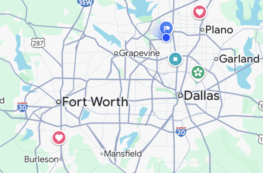
This is a map of the Dallas-Fort Worth (DFW) area in Texas. Yes, we know it looks like a penis. I live near the blue dots at the top right. My husband works near the red heart at the bottom left. That’s about 45 miles and takes an hour most days because both are near highways. Public transit says over 4 hours with three bus/train changes and has a 15 minute walk at each end. Not great when it’s 100F outside.
In many other cities, if you drive 10 miles out of downtown, you can be in the countryside. We can drive 50 miles and be in suburban areas with traffic the entire time. Most people here have a grocery store within 3-4 miles. There are less groceries as you go closer to downtown or in older or cheaper/poorer areas. Convenience stores are closer, but they’re usually gas stations and are pretty expensive for food items. We have several decent restaurants within 5 or 10 miles, but it’s not unusual to drive 20+ miles to go to a favorite restaurant or store or to meet a friend who lives in a different area of town.
In Europe, you can drive for five hours and cross through five cities in three countires. In the US, you can drive five hours and still be in LA.
Walking distance is only part of this equation.
We have no sidewalks and I would need to cross a 6 lane interstate if I were to go to the “closest” anything.
In the suburbs of a middle-sized city in Ohio, USA. So midwest, but a bit older, higher-density, and more northeastern suburban layout than, say, Iowa. Built up in the 1960s-70s. Almost all single-family suburban homes on large lots.
(these are walking distances, not straight lines)
- To the nearest convenience store: 1.6 km
- To the nearest chain supermarket: 4.2 km
- To the bus stop: 1.5 km
- To the nearest park: 226 meters
- To the nearest big supermarket: 2.1 km
- To the nearest library: 2.6 km
- To the nearest train station: Hahaha! (Ok, it’s actually 78 km, but it’s mostly worthless as a train station)
Straight-line distance to Big Ben: 6297 km
I live in a VERY rural area. If I want to visit my neighbors, it’s at the very least a 10 minute walk. To buy groceries it’s about a 20 mi drive. If I want to go to a movie theater, it’s a 40 mile drive. It’s about a 70 mile drive to the closest city (sky scrapers and stuff)
There’s no public transportation or even sidewalks. The closest town that is 5 miles away has one stoplight and a population of 700 ish. We do have a few restaurants in town though, a school and a post office.
Reading your description of the place you live in just reminds me how incredible different people live their lives. Such different lifestyles. I can’t even comprehend living in such a remote place. It’s no wonder that people are divided in almost every way.
You have “a few” restaurants in a town of 700? That’s crazy. I’m also rural, but I have to drive past 2 towns of that size to get to the town of ~3000 just to see a restaurant.
This largely depends on where you are in the US. I have moved a lot over the years, from dense city centers, to the dirt roads of rural America. Here are my experiences:
NYC would probably be the most comparable to your experience in London, but seeing as I haven’t lived there, I can instead talk about Boston. When I lived inside the subway range in Boston (Somerville specifically), my experience matches up with yours. I was ~5 minutes from a supermarket and ~15 minutes from the subway/train stop by foot. I was even closer to a couple bus stops for lines that would take me to places like a mall, nearby universities, or the next subway line over (we don’t have an equivalent of the Circle line).
I currently live in Boston suburbs (Metrowest for people that know the area) and can’t really walk anywhere as my street and adjacent streets don’t have sidewalks. I could try to walk on the street, but with the narrowness combined with the speed at which people drive through this neighborhood, it would not be fun. If I hop in the car, I am ~5 minutes from a strip mall with a supermarket, pharmacy, liquor store, etc. and ~10 minutes from the commuter rail train station that I use to commute to the city for work. If I want to head to a large shopping hub with a mall, then it is ~20 minutes away by car. There is a skeleton of a bus system in my area, but it would require traversing ~1.5 miles on streets without sidewalks to get to the nearest stop for me.
When I lived in a rural area (rural PA), things were very different. To get to the nearest supermarket (a WalMart), it took ~30 minutes worth of driving. If I wanted to go to the mall, it was closer to 60 minutes. I am sure there are even less dense areas than that in this country.
Canadian here but this is pretty much the sentiment I wanted to add. If I was answering for the last city I lived in (400k ish, moderate city for here) it would be a very different answer (<30 minute walk generally anywhere in the “metro” area) than for where I live now (rural, 15 minute drive for grocery in three possible directions, pass at least three cannabis dispensaries on the way to any of them and two liquor stores. Public transit is available but is quasi-regional transit too). So grocery is at 15 minutes, and like in your case a mall is an hour, as is a major market like a Walmart, mega grocer thing, Costco…
many parts of rural Alaska, for example have grocery stores less than a mile away from most of their population, but require planes to get to anything larger.
My closest superstore an hour drive away. 60 miles. The closest grocer is 12 miles. My closest international airport is 1.5 hours away. It is also the closest regional airport. 85 miles. The closest national park is 3 hours. I live 6 miles from my closest town.
There are no passenger trains, busses, or taxis. Or uber.
Rural america is empty. And spread out. We get along fine, but public transit will never exist here. Cars are the only way.
Yep. I live the same life in a very rural and somewhat remote area also. Population density is very low making modern conveniences non-existent and not ever likely to exist in such places.
Other things to consider: Kids often ride a school bus for an hour or more to and from school. Nearest hospital is 40 miles away. And it’s a Level 3. This means it’s pretty much a bandaid station. I used to work as a medic up here. The number of times I had to literally turn the lights on in the ER and wait for the doctor to get out of bed and drive to the hospital would shock you. Nearest ambulance is 20 miles away and you better hope they aren’t already busy when you dial 911. Because if they are, it could be several hours before they can get to you. The US Postal Service will NOT deliver mail to my home. I need to pay $160 a year for a post office box, (no free delivery for me!), and drive the 12 mile round trip to town, (Pop: 150), just to get my mail.
Your measurements are almost exactly mine, down to the closest town.
The railway used to be the default for rural areas. It could be again.
So how does rail solve the Last Mile problem? It does no good to say “take the train” if the nearest train station is 60 miles away. And is it the best use of a train to run tracks to a town/village with a population 150 people or less?
Light rail and buses? Even the most remote rural towns in Japan have small shuttle buses that serve even the sparsest areas. The great thing about public transit is that it is actually scalable if there’s political will to make it happen. A shuttle bus can connect a rural neighborhood to a big train station within 60 minutes. The cool factor of transit is mix and matching several types of transport to cover the most area with the highest mobility for the widest array of people.
Japan still has a higher density of population and far less landmass to cover. My nearest neighbor is over a mile away. Are you going to build a bus route or light rail just for me? Or through county, state, and federal forest lands? Logistics is a bitch.
Only where the rails went. We’d have to replace all the roads with light rails.
It would take more than that. The problem is almost not solvable under present economic and political conditions.
Oh, I agree. There are wide swaths of the country that rail cannot service. Individual homes out in the sticks, farmland, etc. they’d need a car or truck just to get to the train station.
Not for last mile, but should be a much larger part of the picture.
I live in rural Oklahoma…
Here are my walking distances: * To the nearest convenience store: 4.667km * To the nearest chain supermarket: 24.140km * To the bus stop: 27.358km * To the nearest park: 321.869m * To the nearest *big* supermarket: 33.7962km * To the nearest library: 32.1869km * To the nearest train station: 70.8111km
+4600km to the nearest store is like, lots of walking, maybe more than 1h walk. I sad
Yeah, it’s an hour walk one way to that store…
Where I live owning a car is a requirement :(
I moved to Belgium recently, and after 2 months, here i am, buying my first car. Suburbs suck on every contient
I’m also in rural Oklahoma and it is about 9200m for me to get to the closest store, a Dollar General. So I don’t walk, but I do get to live in a beautiful forest next to a lake and stream.
So first of all, the US is big and diverse, if you hop in a car and drive from New York to LA without stopping, taking the fastest route, mostly on major highways, averaging out to something like 60+mph (about 100 km/h) you’re still going to be spending just about 2 days in the car.
And in between, you’re going to see a little bit of everything, mountain, plains, forest, farms, huge dense urban cities, towns small enough you can barely even call them a town, suburban sprawl, massive industrial facilities, you name it you’re going to see it.
Overall, if you live in an urban area, the situation may not be too bad, cities are somewhat walkable, there’s public transportation that will usually get you fairly close to where you need to go, there may even be protected bike lanes, etc. although the situation will vary wildly from one city to another.
It will even vary from one part of the city to another. You can have large sections of the city where there’s no real grocery stores or other places to get your basic necessities, and you’re pretty much limited to whatever you can get from corner stores, bodegas, convenience stores, etc. (mostly pre-packaged and processed foods, and if you’re lucky maybe a couple pieces of fresh fruit) and if you want anything more than that you’re probably looking at taking a few hours out of your day to walk a significant distance to a store or take public transit that may not go exactly where you need it, may be slow, expensive, or just a pain in the ass to deal with, etc.
Getting out into the suburbs, it’s again kind of a crapshoot. There are some walkable suburbs, with wonderful shopping options, there’s some that are a maze of residential developments and gated communities that come off of major roads with no sidewalks or even shoulders worth speaking of and you’re taking a significant gamble trying to walk anywhere from there. There may be little or no public transportation and if there is it may not be going anywhere you need to go, or be convenient to get onto
Personally, I live towards the rural end of the suburbs, about an hour or less from a major city depending on traffic.
Damn near everything I could ever want or need is within about a half hour drive, and most of I commonly need is covered within about 15 minutes.
If I don’t have a car though, my options drop off significantly. I’m looking at an hour walk one way to get to a grocery store, mostly along a long winding road with little or no shoulder and few streetlights. The only things I would really feel safe to walk to are 2 pizza shops, a small hardware store, a bar, a CVS, and gas station/convenience store, those last 2 are going to be about a half hour or longer walk, and along that winding road, but it’s a stretch that at least has a half decent shoulder and some lawns to walk on for most of the way.
If you have a bike, there’s a decent bike trail that will get you to some more shopping options, but it’s about an hour’s ride one way.
If you need to catch public transit, you’d have to walk about 2 hours to catch a bus, that line basically runs straight up and down a main road between the city and a larger, urban-ish town further out in the suburbs. There’s not many options to transfer to anywhere else along the way but there’s a lot along that route so if you can get to that bus most of your needs will be covered, but it doesn’t run super frequently and it’s not going to get you anywhere in a hurry.
Getting out into rural America, you have some small towns that are functionally self-contained, with their own grocery stores and other shopping options in-town within walking distance. Your options are limited but for the most part everything you really need is right there in town.
If you don’t work in town though, and often people in these areas don’t, they may be involved in farming, logging, oil/natural gas, construction, etc. and may work many miles from town, you’re pretty much screwed if you don’t have a car, or at least can count on carpooling with a coworker.
There’s other small towns where there just isn’t much of anything at all, maybe they have a gas station and a liquor store, and if you need anything else you’re SOL, in some cases you may be looking at an hour or more drive to get to anything else so you can forget about walking.
Regardless of where/what kind of area you find yourself in, transportation between cities is often going to be an issue. You can probably catch a Greyhound bus or maybe Amtrak or similar between most major cities, though you may have to get a little creative with figuring out your route, but if you’re trying to get to the smaller towns in between you may not have much luck.
There are, of course, nearly as many exceptions and special cases to everything I said as there are individual towns and cities.
I live on the edge of a small town. Google numbers:
- To the nearest convenience store: 4.7km, 1hr 4min walk
- To the nearest chain supermarket: 21km, 4hr 38min walk
- To the nearest bus stop: 18km, 4hr 7min walk
- To the nearest park: 3.4km, 47 minute walk
- To the nearest library: 4.7km, 1hr 3min walk
- To the nearest train station: 20km, 4hr 31 minute walk
I live in DFW, a large amalgamation of two cities and a bunch if suburban sprawl in Texas.
I live in a neighborhood that is considered extremely walkable, as I am directly across the street from a university and less than a mile from city hall.Here are my walking distances:
- To the nearest convenience store: 1.8km
- To the nearest chain supermarket: 4.3 km (They have a monopoly though, so unless you can afford whole foods, the closest good one is like 22.5 km)
- To the bus stop: Lol, we don’t have busses. A neighboring city does, so I guess 29 km?
- To the nearest park: Nearest park is 2.8km. Nearest public space is only 1.5km because I live right next to city hall.
- To the nearest big supermarket: 8.9 km to Walmart.
- To the nearest library: 1.5km, again, I live right next to city hall.
- To the nearest train station: 16km, unless you mean one for intercity travel. We don’t have one of those because Amtrak is slowly being killed.
Straight-line distance to Big Ben: we don’t have a Big Ben, but we killed JFK and that’s 34km away.
Bonus fun fact, I commute 42km each day. This is considered far by most people here, 32km would be much more reasonable.
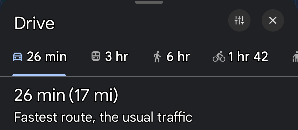
To reiterate how bad public transit is, even in populated areas: I’m also in DFW. This is my daily commute…
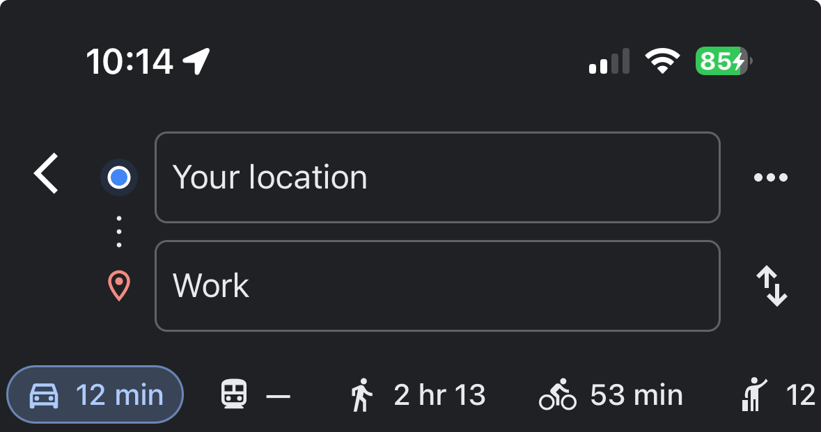
It’s ~9.6km. Note that the bus/train option is entirely greyed out, because there is no public transit which runs from my house to my job. If I were to walk, the only option would be on the side of a highway. I would have cars passing me at ~70 MPH without even a curb for protection.
To walk to the nearest grocery store, it’s ~4km, with a large part of it along the shoulder of that same highway. Same with a major chain.
Nearest bus stop is ~6.9km, but that only takes me in a direction I wouldn’t need to go; There are no local bus or train stops that land me near where I work or live.
I’m in the Indianapolis area, and we do have public transit… though I don’t know why.
Depends where you live.
In a city? 75% of everything I need is right across the street.
In a rural town? Before I moved to the city, I had to drive 30-45 miles away to do literally anything. There were busses, but they only came around once in the morning and once more in the evening. And they didn’t always go where you wanted directly, so you’d have to spend like an entire day just to get to a place.
Nearest big landmark everyone might recognize is the Golden Gate Bridge in San Francisco. And thats 78 miles away in a straight line.
Edit: To put things in terms non-Americans may understand better - We tend to measure distances not in the unit of distance, but in the time it takes to get somewhere. Assuming there is no traffic, the Golden Gate Bridge would only be an hour away taking the freeway. But that’s never gonna happen; the traffic through the Altamonte Pass alone is gonna add 1-2 hours depending on the time of day.
At my current job, I’m about 45 minutes away by car. Car is also the only option. Before I moved closer, I was actually an hour and a half away, so 90 minutes one way, or 3 hours per day worth of driving.
It’s too expensive to live in the cities themselves, so I have to live further out and just commute.
Closest wal-mart is about 30 minutes away, but there’s smaller stores closer if I dont’t need much.
I haven’t mentioned walking/biking because there’s no point in walking where I live. There’s next to no shoulder on the road, and it’s 45MPH (72KPH) roads with mostly large pickup trucks driving on it, so it’s not safe to walk.
For reference, I live in the American south, so it’s somewhat rural.
The big thing to know is that things spread out as you go from East to West.
On the East Coast, New England area, everything is pretty tightly packed. On the West Coast? Not so much.
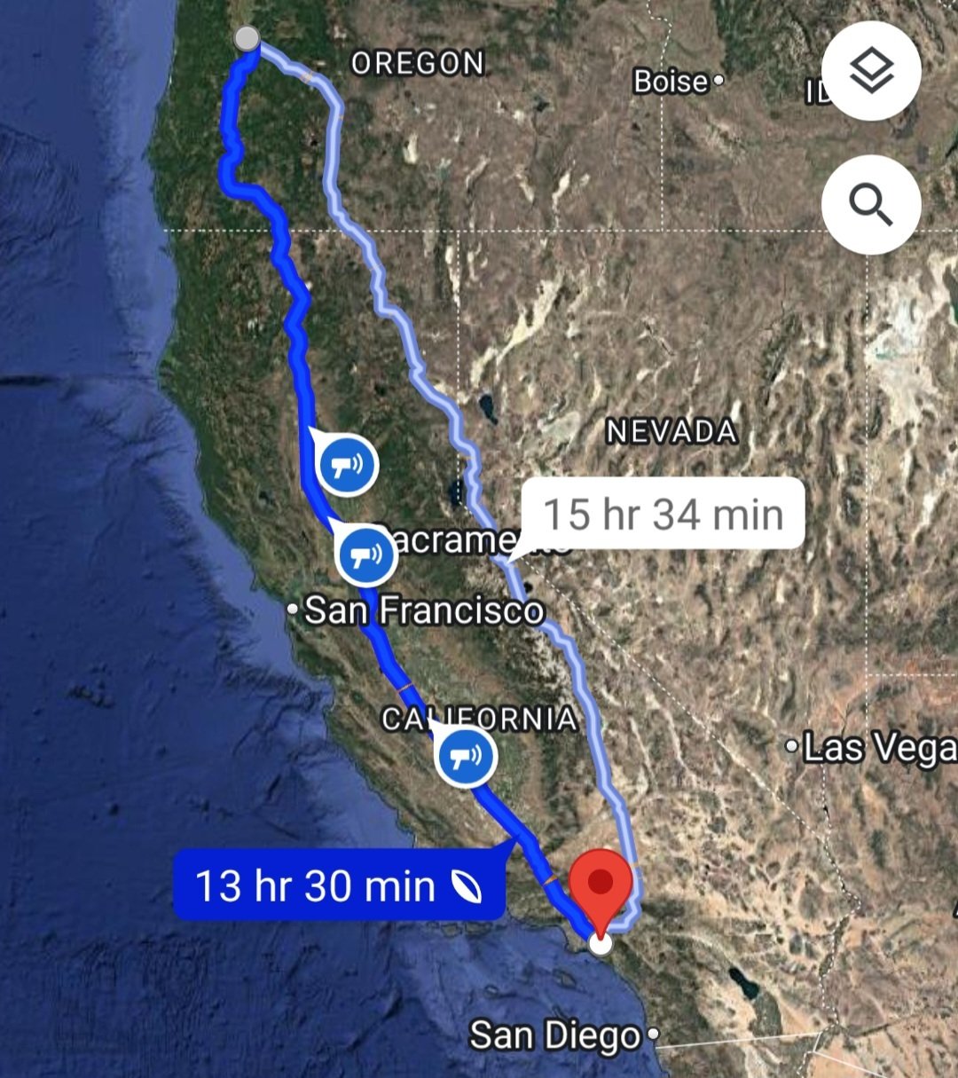
When I was living in Eugene, Oregon, I had family visit from Sweden, so we asked them what they wanted to do.
“We want to go to Disneyland!”
OK, not saying we CAN’T, but it’s 13 hours in the car assuming no traffic.